New Philadelphia App Will Predict Vacant Properties

In a big city like Philadelphia, all too often vacancy equals blight. It’s a constant struggle by city officials to keep an eye on vacant buildings to ensure that squatters haven’t moved in, or that the buildings haven’t fallen into dangerous states of disrepair. Looking back, the Market Street building collapse of 2013 is a good example of the deadly dangers posed by vacant buildings. Now, a new app will help Philadelphia stay abreast of vacant buildings by accurately predicting which ones are without inhabitants.

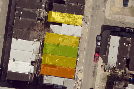
Courtesy of Technically Philly, this image shows LIDAR imaging on the city of Philadelphia’s vacancy app.
There are approximately 40,000 vacant buildings in Philadelphia. The new app, which debuted last week at Philadelphia’s Innovation Lab, is the brainchild of multiple city agencies working together, including the Department of Licenses & Inspections, the Office of Innovation and Technology and the Water Department. The app’s developers say that the technology behind the app relies on multiple types of data to tell Philadelphia’s 50 property inspectors which buildings should be prioritized. Data sets include property violations and water shutoffs.
The app will also utilize aerial LIDAR images to identify holes in the roofs of structures that inspectors might otherwise miss. According to the Philly Voice, LIDAR “visualize[s] distance by illuminating targets with laser and analyzing reflected light.”
Departments throughout the city raised $800,000 to cover the costs of the app, much of which went to the LIDAR survey and analysis. The app will be utilized to boost the efficacy of other government tech solutions,including L & I’s app to pick up unsafe structures and make an educated guess as to the public danger they pose based on the buildings’ nearness to close-by bus stops and homes.
It was not stated whether the app will be available to the public.


